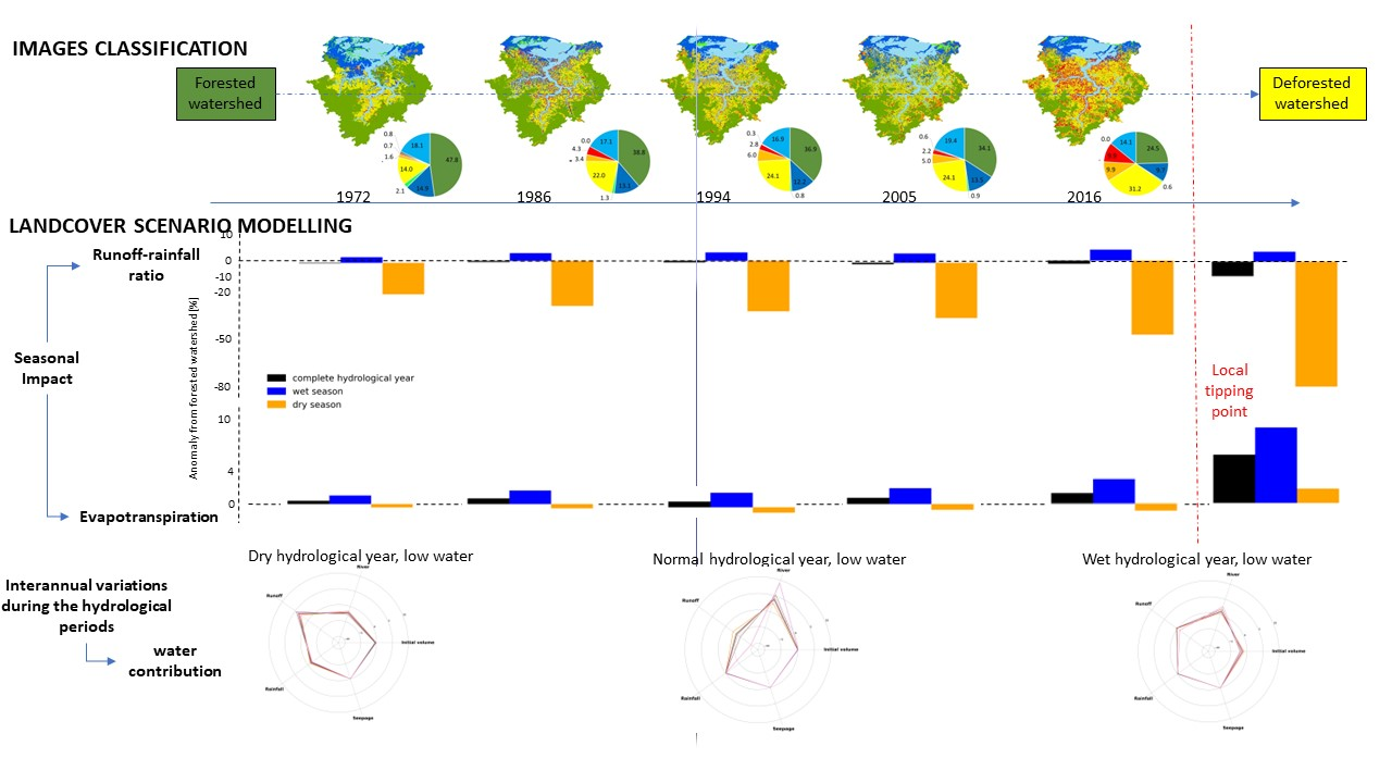
The spatio-temporal land cover dynamics of a medium‐size floodplain system along the Amazon/Solimões River (Janauacá Lake, 786 km 2) and their hydrological impacts are studied through remote sensing and modeling. Hence, the analysis of 5 satellite-derived land cover maps (1972-2016 period) reveals a decrease in natural environments (from 65% to 35%) to the benefit of anthropic classes (from 17% to 51%) through deforestation vectors (two highways and lake banks). Deforestation is a non-stationary process with significant increase over specific subperiods (1972-1986, and 2005-2016). It occurs in stages with conversions into secondary vegetation then into non-natural environments. 7 land cover scenarios (5 satellite-derived, 1 deforested and 1 forest, used as reference) are used as inputs to run simulations with the same meteorology over the 2006-2018 period. Beside high ( ≥ 24%) and low ( ≤ 7%) interannual variability of runoff-rainfall ratio (RRR) and evapotranspiration (ET), the numerical experiments evidence, on an annual scale, the RRR decreases and the ET increases with deforestation increases. Deforested scenario suggests a convergence: for the RRR, around 0.34 (-87%) and for the ET, around 1146 mm.yr -1 (+6%). At the seasonal scale, the landuse/landcover changes (LUCC) induce positive wet season ET anomaly (<9%) and large negative dry season RRR anomaly (-87%). The highest LUCC-induced disturbances (from -15% to 18%) in the FP mixture are recorded at seasonal scale, during LW and RW and, at interannual scale, during dry and normal HY. The LUCC-induced disturbances patterns of FP mixture mainly concern river and runoff. They are different regarding the hydrological period or HY type. Our experiments suggest the existence of a tipping point between present land cover (2016) and fully deforested cover associated with reversal phenomena and enhancing of seasonal and interannual LUCC-induced disturbance. At last, the model shows the LUCC augment the vulnerability associated with drought periods.