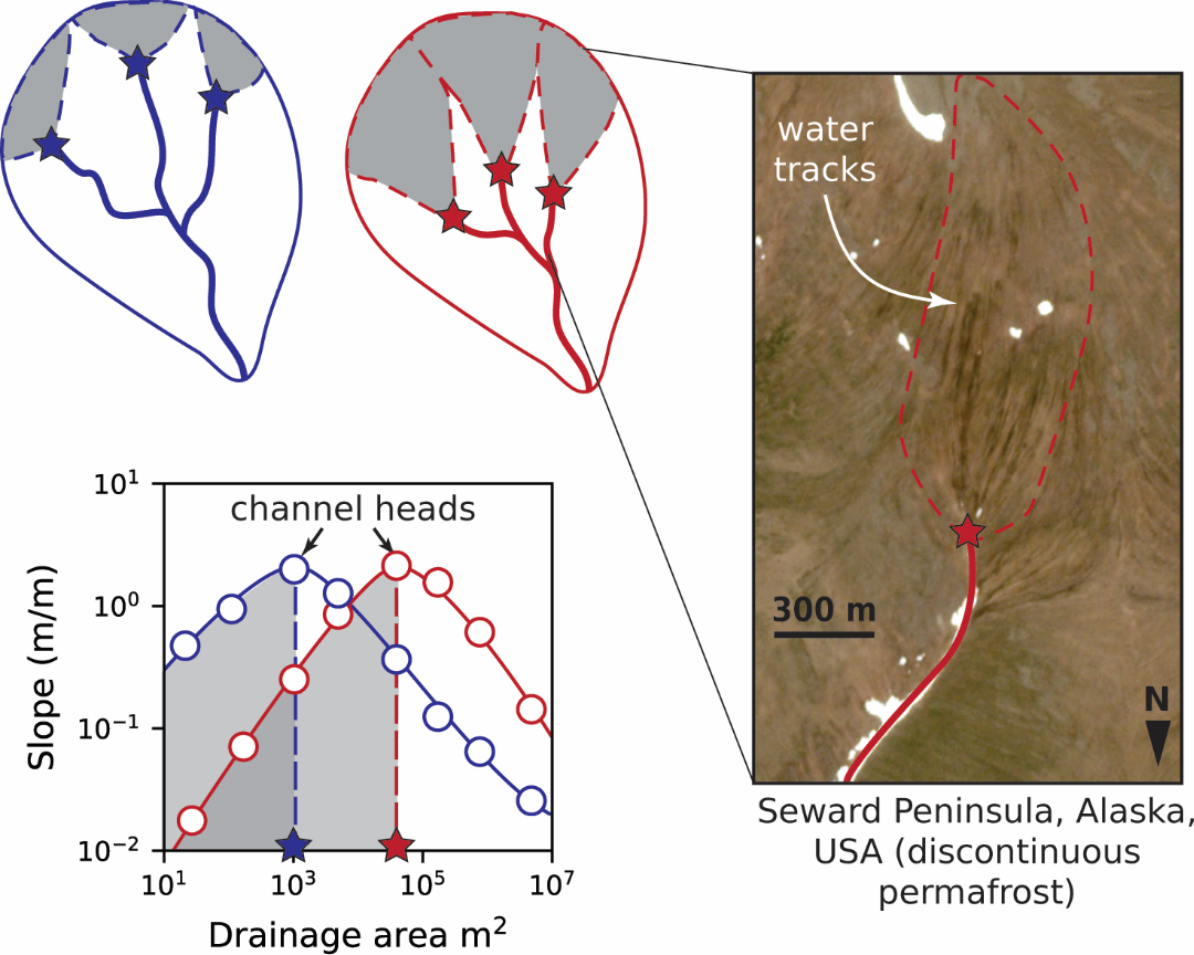
Joanmarie Del Vecchio1,2, Simon Zwieback3, Joel C. Rowland4, Roman A. DiBiase5,6, Marisa C. Palucis11Department of Earth Science, Dartmouth College, Hanover, NH, USA2Neukom Institute for Computational Science, Dartmouth College, Hanover, NH USA3Department of Geosciences, University of Alaska Fairbanks, Fairbanks, AK USA4Earth and Environmental Sciences Division, Los Alamos National Laboratory, NM USA5Department of Geosciences, Pennsylvania State University, University Park, Pennsylvania 16803, USA6Earth and Environmental Systems Institute, Pennsylvania State University, University Park, Pennsylvania 16803, USACorresponding author: Joanmarie Del Vecchio ([email protected])Key Points:Seasonal and long-term permafrost thaw change hillslope hydrology and erodibilitySatellites observe surface displacements concentrated in certain landscape positionsA conceptual model is proposed for hillslope-channel coupling in permafrost landscapes mediated by water tracksAbstractThe Arctic is experiencing rapid climate change, and the effect on hydrologic processes and resulting geomorphic changes to hillslopes and channels is unclear because we lack quantitative models and theory for landscape evolution in thawing permafrost. The presence of permafrost modulates water infiltration and flow and the stability of soil-mantled slopes, implying there should be a topographic “signature” of permafrost processes, including warming-driven disturbance. To inform predictions of hillslope-channel dynamics under changing climates, we examined soil-mantled hillslopes within a ~ 300 km2 area of the Seward Peninsula, western Alaska, where discontinuous permafrost is particularly susceptible to thaw and rapid landscape change. In this study we pair high-resolution topographic and satellite data to multiannual observations of InSAR-derived surface displacement over a five-year period to quantify spatial variations in topographic change across an upland landscape. We find that neither basin slope nor the presence of knickzones controls the magnitude of recent surface displacements within the study basin, as may be expected under conceptual models of temperate hillslope evolution. Rather, the highest displacement magnitudes tended to occur at the broad hillslope-channel transition zone. In this study area this zone is occupied by water tracks which are zero-order ecogeomorphic features that concentrate surface and subsurface flow paths. Our results suggest that water tracks, which we hypothesize occupy hillslope positions between saturation and incision thresholds, are vulnerable to warming-induced subsidence and incision. We expect gullying within water tracks to outpace infilling by hillslope processes, resulting in growth of the channel network under future warming.