Manuel Diercks

and 4 more

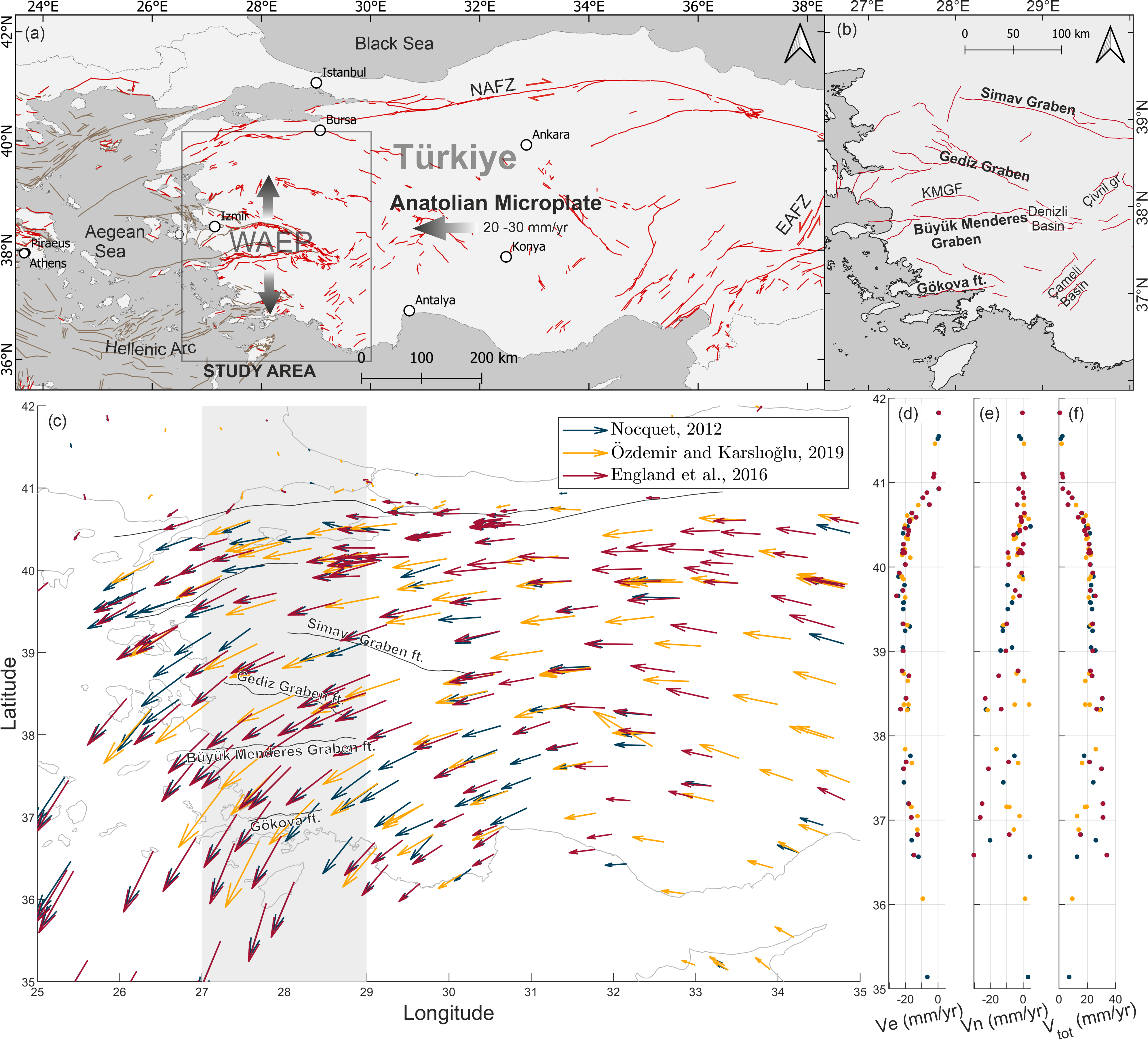
Quantifying interseismic deformation of fault networks which are predominantly deforming in a north-south direction is challenging, because GNSS networks are usually not dense enough to resolve deformation at the level of individual faults. The alternative, synthetic aperture radar interferometry (InSAR), provides high spatial resolution but is limited by a low sensitivity to N-S motion. We study the active normal fault network of Western Anatolia, which is undergoing rapid N-S extension, using InSAR. In the first part of this study, we develop a workflow to assess the potential of decomposing InSAR line-of-sight (LOS) velocities to determine the N-S component. We use synthetic tests to quantify the impact of noise and other velocity components and outline the requirements to detect N-S deformation in future studies. In its current state, the N-S deformation field is too noisy to allow robust interpretations, hence in the second part we complement the study by including vertical deformation. Since most faults in the study region are normal faults, the high-resolution vertical velocity field provides new insights into regional active faulting. We show that tectonic deformation in the large graben systems is not restricted to the main faults, and seemingly less active or inactive faults could be accommodating strain. We also observe a potential correlation between recent seismicity and active surface deformation. Furthermore, we find that active fault splays causing significant surface deformation can form several kilometres away from the mapped fault trace, and provide an estimate of current activity for many faults in the region.

Joshua Nathan Jones

and 4 more

Landslide susceptibility models are fundamental components of landslide risk management strategies. These models typically assume that landslide occurrence is time-independent, even though processes including earthquake preconditioning and landslide path dependency transiently impact landslide occurrence. Understanding the temporal characteristics of landslide occurrence remains limited by a lack of systematic investigation into how landslide distributions vary through time, and how this impacts landslide susceptibility. Here, we apply Kolmogorov-Smirnoff and Chi-2 statistics to a 30-year inventory of monsoon-triggered landslides from Nepal to systematically quantify how landslide spatial distributions vary through time in ‘normal’ years and years impacted by extreme events. We then develop Binary Logistic Regression (BLR) susceptibility models for 12 years in our inventory with > 400 landslides and use Area Under Receiver Operator Curve (AUROC) validation to assess how well these models can hindcast landslide occurrence in other years. Landslide distributions are found to vary through time, particularly in years impacted by storms (1993 and 2002), earthquakes (2015) and floods (2017). Notably, Gorkha earthquake landscape preconditioning shifted 2015 monsoon-triggered landslides to higher slopes, reliefs and excess topographies. These variations significantly impact BLR susceptibility modelling, with models trained on extreme years unable to consistently hindcast landslide occurrence in other years. However, developing BLR models using increasingly long historical inventories shows that susceptibility models developed using > 6 - 8 years of landslide data provide consistently good hindcasting accuracy. Overall, our results challenge time-independent assumptions of landslide susceptibility approaches, highlighting the need for time-dependent modelling techniques or historical inventories for landslide susceptibility modelling.

Jesse Zondervan

and 10 more

Structural and lithological controls in mountain valleys have been shown to affect the erosional connectivity of hillslopes, tributaries and alluvial fans, as well as the formation and preservation of strath terraces. In this study we explore the synchronicity of fluvial bedload aggradation and bedrock incision in valleys of one river draining a collisional mountain belt through geomorphological, sedimentological and chronological datasets of strath terraces. Along the M’Goun River on the southern flank of the central High Atlas Mountains strath surfaces and bedload sediments are preserved in valleys with differing structure and lithology throughout the thrust front and wedge-top basin. We (1) extract terrace surface and river channel elevations from a digital elevation model and field mapping to reconstruct river long profiles; (2) collect grain size and lithology data from terraces to derive information on sediment source and transport; (3) constrain the timing of bedload aggradation within the two latest strath levels using a new approach to OSL dose rate correction of gravels. Strath terraces form in weak sedimentary bedrock in valleys confined by limestone and conglomerate units, and are capped by up to 3 to 10 m of gravel bedload and overbank sands. The record of strath burial and incision extends to 180 ka, but only includes one synchronous bedload aggradation event during the last interglacial maximum MIS 5a (~130-110 ka). Reconstructed paleo-river long profiles and chronology demonstrate time-transgressive bedrock incision through the thrust front and wedge-top basin on the order of 10^4 – 10^5 yrs, representing strath incision of 12 to 40 m. A lack of a downstream bedload grain-size trend and presence of locally derived clast lithologies indicate lateral input of gravel from valleys in addition to downstream transport. These results allow for the development of a conceptual model of asynchronous strath terrace formation in a collisional mountain belt.

Jesse Zondervan

and 10 more

The effects of climate on eroding landscapes and the delivery of sediment from these remain poorly understood. The sampling and dating of river terraces provide one way to address this question, because these embed information about the interconnected dynamics of mountain valley widening, river incision, sediment delivery, and their sensitivity to external forcing. We developed a new approach to OSL dose rate correction of gravels to derive the most detailed chronology of river terrace stratigraphy in NW Africa to date. We sampled river terraces 10-20 m above the modern river plain for dating in a 1200 km2 river catchment, the River M’Goun, eroding the High Atlas Mountains hinterland of the continental river Draa. We applied OSL and IRSL dating to determine the age of 23 samples, using Bayesian methods to derive a robust chronology. We show terrace strath planation starts at ~180 ka in the MIS 6 glacial maximum, followed by aggradation from 140 – 57 ka in MIS 5 to MIS 4 which deposited the up to 10 m stratigraphy of fluvial conglomerate (imbricated rounded cobbles). Incision and abandonment of river terraces occur in MIS 3 to 2 during the transition to the last glacial maximum. Our results compared with an Atlantic record of aridity in the Northern Sahara over the last 120 ka show that aggradation and valley widening occur in response to periods of northward penetration of the African summer monsoon into the High Atlas. We note that these signals persist across the different tectonic zones, from the fold and thrust belts into the sedimentary basins. More widely, our data demonstrate how changes in monsoon patterns can cause changes in the erosion of mountains and transport of sediment in arid continental interiors and these form new inputs for numerical landscape evolution models.