Robert Ehlert

and 4 more

Across diverse biomes and climate types, plants use water stored in bedrock to sustain transpiration. Bedrock water storage ($S_{bedrock}$, mm), in addition to soil moisture, thus plays an important role in water cycling and should be accounted for in the context of surface energy balances and streamflow generation. Yet, the extent to which bedrock water storage impacts hydrologic partitioning and influences latent heat fluxes has yet to be quantified at large scales. This is particularly important in Mediterranean climates, where the majority of precipitation is offset from energy delivery and plants must rely on water retained from the wet season to support summer growth. Here we present a simple water balance approach and random forest model to quantify the role of $S_{bedrock}$ on controlling hydrologic partitioning and land surface energy budgets. Specifically, we track evapotranspiration in excess of precipitation and mapped soil water storage capacity ($S_{soil}$, mm) across the western US in the context of Budyko’s water partitioning framework. Our findings indicate that $S_{bedrock}$ is necessary to sustain plant growth in forests in the Sierra Nevada — some of the most productive forests on Earth — as early as April every year, which is counter to the current conventional thought that bedrock is exclusively used late in the dry season under extremely dry conditions. We show that the average latent heat flux used in evapotranspiration of $S_{bedrock}$ can exceed 100 $W/m^{2}$ during the dry season and the proportion of water that returns to the atmosphere would decrease dramatically without access to $S_{bedrock}$.

W. Jesse Hahm

and 4 more

Quantifying evapotranspiration is critical to accurately predict vegetation health, groundwater recharge, and streamflow generation. Hillslope aspect, the direction a hillslope faces, results in variable incoming solar radiation and subsequent vegetation water use that influence the timing and magnitude of evapotranspiration. Previous work in forested landscapes has shown that equator-facing slopes have higher evapotranspiration due to more direct solar radiation and higher evaporative demand. However, it remains unclear how differences in vegetation type (i.e., grasses and trees) influence evapotranspiration and water partitioning between hillslopes with opposing aspects. Here, we quantified evapotranspiration and subsurface water storage deficits between a pole- and equator-facing hillslope with contrasting vegetation types within central coastal California. Our results suggest that cooler pole-facing slopes with oak trees have higher evapotranspiration than warmer equator-facing slopes with grasses, which is counter to previous work in landscapes with singular vegetation types. Our water storage deficit calculations indicate that the pole-facing slope has a higher subsurface storage deficit and a larger seasonal dry down than the equator-facing slope. This aspect difference in subsurface water storage deficits may influence subsequent deep groundwater recharge and streamflow generation. In addition, larger root-zone storage deficits on pole-facing slopes may reduce their ability to serve as hydrologic refugia for oaks during periods of extended drought. This research provides a novel integration of field-based and remotely-sensed estimates of evapotranspiration required to properly quantify hillslope-scale water balances. These findings emphasize the importance of resolving hillslope-scale vegetation structure within Earth system models, especially in landscapes with diverse vegetation types.

Emma C. Sevier

and 6 more

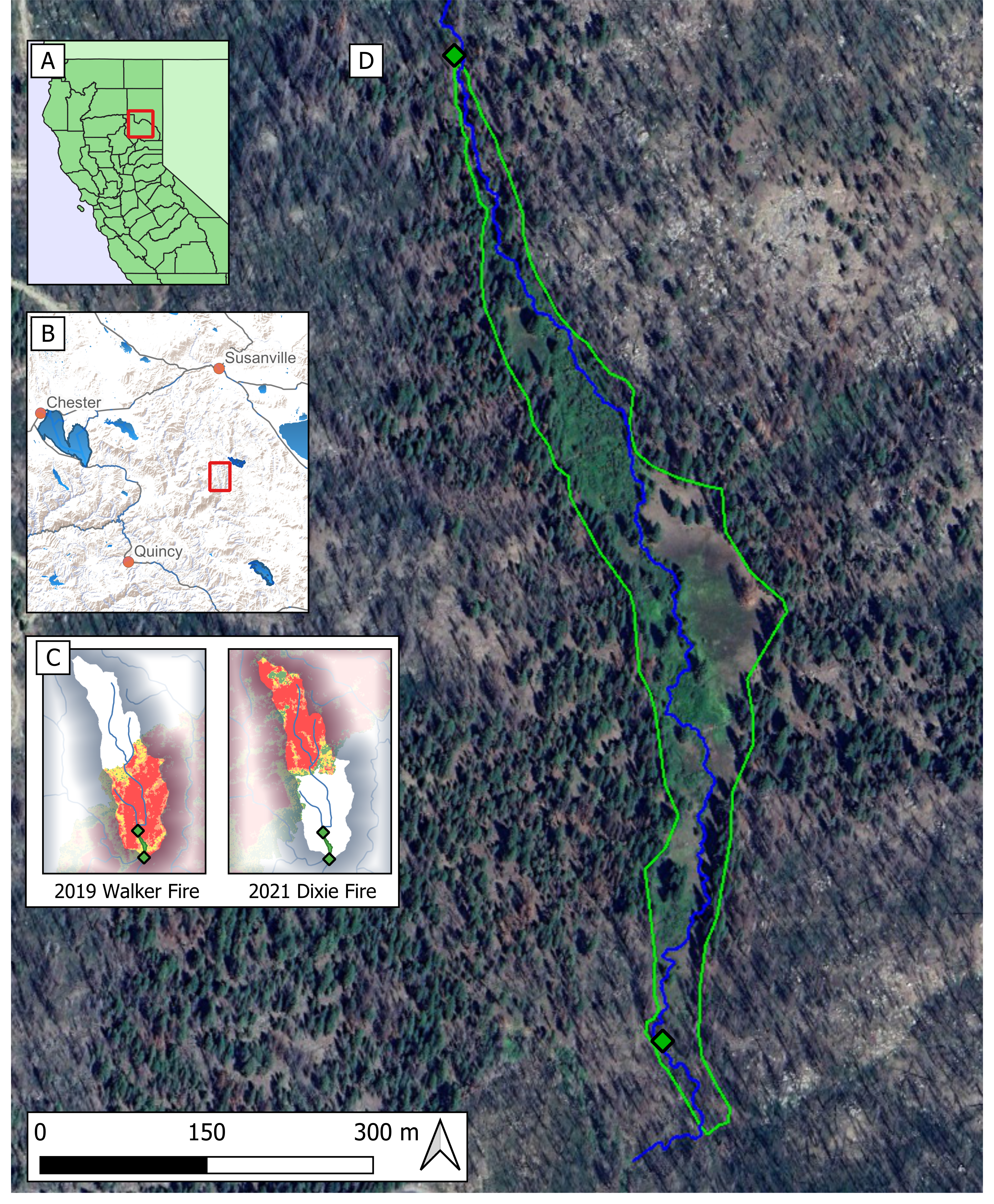
Mountain meadows are ecologically important, but often degraded, groundwater dependent ecosystems that retain and store water in upland forested landscapes. They tend to occur in low-gradient, broad valleys where water naturally slows and sediment accumulates, making them efficient locations for restoration. Over a century and a half of land use has degraded many meadows in the Sierra Nevada, reducing their hydrological and ecological functionality. Process-based restoration is a potentially economical and scalable restoration approach for numerous, small, remote, degraded mountain meadows. The approach uses onsite materials and leverages fluvial processes to achieve restoration objectives including increases in wetted area, groundwater elevations, sediment capture, and development of multithreaded channels. These changes in hydrological functionality can lead to improved ecological function over time. This study compares pre- and post-restoration surface and groundwater conditions in a degraded riparian meadow in the Sierra Nevada, California U.S.A. to understand changes in meadow hydrogeomorphic function following process-based restoration. Restoration included the installation of 35 postless beaver dam analog structures in ~1 km of incised meadow channel. Stage-discharge data at the inlet and outlet of the project area were paired with groundwater data collected from 15 wells distributed across the meadow in a power law model to estimate increased water storage of 3700 m 3 (~3 acre-ft) due to restoration. After the wet winter of 2023, we estimated that pools behind structures filled to over half their volume with fine sediment. We also applied hydrodynamic modeling to evaluate fluvial changes at high flows and found that restoration increased flow complexity and wetted surface area. These short-term responses highlight the potential speed and effectiveness of low-tech, process-based restoration in achieving desired restoration outcomes.
Understanding how soil thickness and bedrock weathering vary across ridge and valley topography is needed to constrain the flowpaths of water and sediment production within a landscape. Here, we investigate saprolite and weathered bedrock properties across a ridge-valley system in the Northern California Coast Ranges, USA, where topography varies with slope aspect such that north facing slopes have thicker soils and are more densely vegetated than south facing slopes. We use active source seismic refraction surveys to extend observations made in boreholes to the hillslope scale. Seismic velocity models across several ridges capture a high velocity gradient zone (from 1000 to 2500 m/s) located ~4-13 m below ridgetops, that coincides with transitions in material strength and chemical depletion observed in boreholes. Comparing this transition depth across multiple north and south-facing slopes, we find that the thickness of saprolite does not vary with slope aspects. Additionally, seismic survey lines perpendicular and parallel to bedding planes reveal weathering profiles that thicken upslope and taper downslope to channels. Using a rock physics model incorporating seismic velocity, we estimate the total porosity of the saprolite and find that inherited fractures contribute a substantial amount of pore space in the upper 6 m, and the lateral porosity structure varies strongly with hillslope position. The aspect-independent weathering structure suggests the contemporary critical zone structure at Rancho Venada is a legacy of past climate and vegetation conditions.