Geomorphic and stratigraphic studies of Mars prove extensive liquid water flowed and pooled on the surface early in Mars’ history. Martian paleoclimate models, however, have difficulty simulating climate conditions warm enough to maintain liquid water on early Mars. Reconciling the geologic record and paleoclimatic simulations of Mars is critical to understanding Mars’ early history, atmospheric conditions, and paleoclimate. This study uses an adapted lake energy balance model to investigate the connections between Martian geology and climate. The Lake Modeling on Mars for Atmospheric Reconstructions and Simulations (LakeM2ARS) model is modified from an earth-based lake model to function in Martian conditions. We use LakeM2ARS to investigate conditions necessary to simulate a lake in Gale crater. Working at a localized scale, we combine climate input from the Mars Weather Research & Forecasting general circulation model with geologic constraints from Curiosity rover observations; in doing so, we identify potential climatic conditions required to maintain a seasonal liquid lake. We successfully model lakes in Gale crater while varying initial climate conditions, lake size, and water salinity. Our results show that ice-free conditions in a plausible Gale crater lake are best supported when the lake is small, ~10 m deep, and air temperatures reach or are just above freezing seasonally during a Martian year. Continued use and iteration of LakeM2ARS will strengthen connections between Mars’ paleoclimate and geology to inform climate models and enhance our understanding of conditions on early Mars.
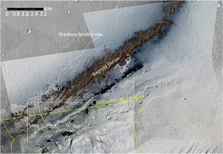
The Bagnold linear dune field investigated by Curiosity at Mount Desert Island (MDI) is in Gale crater, north of the ~5.5 km high Aeolis Mons mound. False-color images (RGB, 2.496, 1.802, and 1.235 μm, respectively) generated from Mars Reconnaissance Orbiter (MRO) Compact Reconnaissance Imaging Spectrometer for Mars (CRISM) data show the dune field has a reddish-brown color. A sand sheet located south of the Bagnold dunes, the Sands of Forvie (SoF), is darker and lacks the reddish-brown color. Single scattering albedo (SSA) spectra retrieved at 12 m/pixel using along‑track oversampled CRISM observation FRT00021C92 show a long wavelength (1.7 to 2.5 μm) rise for the MDI dunes. Over the same wavelength interval, SoF is characterized by a broad ~2.2 μm absorption feature, consistent with color differences between the two deposits. Checkerboard unmixing of the SSA image cube isolated spectral endmembers within the MDI and SoF. Nonlinear modeling using Hapke (2012) theory implies finer grain sizes for MDI compared to SoF, with inferred abundances of basaltic glass > feldspar > olivine > pigeonite > augite for MDI, and basaltic glass > feldspar > augite > olivine for SoF. These results are similar for the mean spectra of each region and coincide with Curiosity‑based observations that MDI contains smaller ripples with overall finer grains, while SoF has large megaripples and concentrated coarser grains on the crests. Although these deposits are only located ~2.5 kilometers away from one another, wind and local topographic controls influence their grain size and mineralogy.