Yunxiang Chen

and 16 more

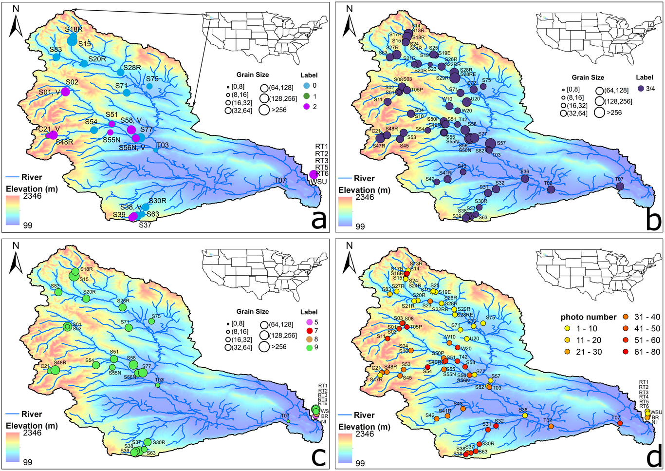
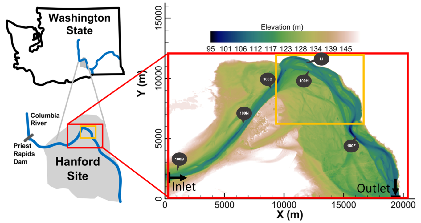
Streambed grain sizes and hydro-biogeochemistry (HBGC) control river functions. However, measuring their quantities, distributions, and uncertainties is challenging due to the diversity and heterogeneity of natural streams. This work presents a photo-driven, artificial intelligence (AI)-enabled, and theory-based workflow for extracting the quantities, distributions, and uncertainties of streambed grain sizes and HBGC parameters from photos. Specifically, we first trained You Only Look Once (YOLO), an object detection AI, using 11,977 grain labels from 36 photos collected from 9 different stream environments. We demonstrated its accuracy with a coefficient of determination of 0.98, a Nash–Sutcliffe efficiency of 0.98, and a mean absolute relative error of 6.65% in predicting the median grain size of 20 testing photos. The AI is then used to extract the grain size distributions and determine their characteristic grain sizes, including the 5th, 50th, and 84th percentiles, for 1,999 photos taken at 66 sites. With these percentiles, the quantities, distributions, and uncertainties of HBGC parameters are further derived using existing empirical formulas and our new uncertainty equations. From the data, the median grain size and HBGC parameters, including Manning’s coefficient, Darcy-Weisbach friction factor, interstitial velocity magnitude, and nitrate uptake velocity, are found to follow log-normal, normal, positively skewed, near log-normal, and negatively skewed distributions, respectively. Their most likely values are 6.63 cm, 0.0339 s·m-1/3, 0.18, 0.07 m/day, and 1.2 m/day, respectively. While their average uncertainty is 7.33%, 1.85%, 15.65%, 24.06%, and 13.88%, respectively. Major uncertainty sources in grain sizes and their subsequent impact on HBGC are further studied.

Sushant Mehan

and 14 more

This article comprises three independent commentaries about the state of ICON principles in hydrology and discusses the opportunities and challenges of adopting them. Each commentary focuses on a different perspective as follows: (i) field, experimental, remote sensing, and real-time data research and application (Section 1); (ii) Inclusive, equitable, and accessible science: Involvement, challenges, and support of early career, marginalized racial groups, women, LGBTQ+, and/or disabled researchers (Section 2); and (iii) an ICON perspective on machine learning for multiscale hydrological modeling (Section 3). Hydrologists depend on data monitoring, analyses, and simulations from these diverse scientific disciplines to ensure safe, sufficient, and equal water distribution. These hydrologic data come from but are not limited to primary (in-situ: lab, plots, and field experiments) and secondary sources (ex-situ: remote sensing, UAVs, hydrologic models) that are typically openly available and discoverable. Hydrology-oriented organizations have pushed our community to increase coordination of the protocols for generating data and sharing model platforms. In addition, networking at all levels has emerged with an invigorated effort to activate community science efforts that complement conventional data collection methods. With increasing amounts of data, it has become difficult to decipher various complex hydrologic processes. However, machine learning, a branch of artificial intelligence, provides accurate and faster alternatives to understand different biogeochemical and hydrological processes better. Diversity, equity, and inclusivity are essential in terms of outreach and integration of peoples with historically marginalized identities into this professional discipline and respecting and supporting the local environmental knowledge of water users.

Yunxiang Chen

and 10 more

Quantifying the multiscale feedback between hydrodynamics and biogeochemistry is key to reliable modeling of river corridor systems. However, accurate and efficient hydrodynamics models over large spatiotemporal scales have not yet been established due to limited surveys of riverbed roughness and high computational costs. This work presents a semi-automated workflow that combines topographic and water stage surveys, computational fluid dynamics modeling, distributed wall resistance modeling, and high-performance computing to simulate flow in a 30-kilometer-long reach at the Columbia River during 2011-2019. The results show that this workflow enables a high accuracy in modeling water stage at all seven survey locations during calibration (1 month) and validation (65 months) periods. It also enables a high computational efficiency to model the streamflow during a 58-month solution-time within less than a 6-day wall-clock-time with mesh number, time step, and CPU hours of about 1.2 million, 3 seconds, and 1.1 million hours, respectively. Using the well-validated results, we show that riverbed dynamic pressure is randomly distributed over all spatiotemporal scales with its cross-sectional average values approximately quantified by a normal distribution with a mean and standard deviation of -0.353 m and 0.0352 m; bed shear stress is affected by flowrate and large- and small-scale topographic features with cross-sectional maximum values following a smooth but asymmetric distribution with 90% of its value falling between 5 Pa and 35 Pa; and hydrostatic pressure is influenced by flowrate and large-scale topographic features with cross-sectional maximum values quantified by a discontinuous and skewed distribution determined by streamwise topographic variations.

Acharya Bharat Sharma

and 14 more

Hydrologic sciences depend on data monitoring, analyses, and simulations of hydrologic processes to ensure safe, sufficient, and equal water distribution. These hydrologic data come from but are not limited to primary (lab, plot, and field experiments) and secondary sources (remote sensing, UAVs, hydrologic models) that typically follow FAIR Principles (FAIR Principles - GO FAIR (go-fair.org)). Easy availability of FAIR data has become possible because the hydrology-oriented organizations have pushed the community to increase coordination of the protocols for generating data and sharing model platforms. In addition, networking at all levels has emerged with an invigorated effort to activate community science efforts that complement conventional data collection methods. However, it has become difficult to decipher various complex hydrologic processes with increasing data. Machine learning, a branch of artificial intelligence, provides more accurate and faster alternatives to better understand different hydrological processes. The Integrated, Coordinated, Open, Networked (ICONs) framework provides a pathway for water users to include and respect diversity, equity, and inclusivity. In addition, ICONs support the integration of peoples with historically marginalized identities into this professional discipline of water sciences. This article comprises three independent commentaries about the state of ICON principles in hydrology and discusses the opportunities and challenges of adopting them.