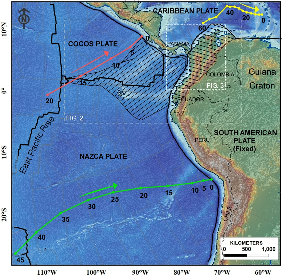
The interaction of the northern Nazca and southwestern Caribbean oceanic plates with South America, and the collision of the Panama-Choco arc have significant implications on the evolution of the northern Andes. We integrate an alternative interpretation of the Nazca and Caribbean kinematics with the magmatic and deformation history in the region. The northeastward migration of the Caribbean plate caused a progressive change in the geometry of the subducting Farallon plate, causing flat-slab subduction throughout the late Eocene-late Oligocene, inhibition of magmatism and eastward migration of the Andean deformation. Meanwhile, the Paleocene-Eocene highly oblique convergence of the Caribbean plate against South America changed by the mid-Eocene, when the Caribbean plate began to migrate in an easterly direction. These events and the late Oligocene breakup of the Farallon plate, prompted a Miocene plate reorganization, with further plate fragmentation, changes in convergence obliquity, steepening of the subducting slabs and renewal of magmatism. This tectonics was complicated by the accretion of the Panama-Choco arc to South America, which was characterized by early Miocene subduction erosion of the forearc and trench advance, followed by breakoff of the subducting slab east of Panama and collisional tectonics from the middle Miocene. By 9 Ma the Coiba and Malpelo microplates were attached to the Nazca plate, resulting in an abrupt change in convergence directions, that correlates with the main pulse of Andean orogeny. During the late Pliocene, the Nazca slab broke, triggering the modern volcanism south of 5.5º N. Seismicity data and tomography support the proposed reconstruction.
Much information about the North American lithosphere has been gained by imaging seismic wave velocities. Additional constraints on the state of the subsurface can be gained by studying seismic attenuation, which has different sensitivity to physical properties. We produce a model of lateral variations in attenuation across the conterminous U.S. by analyzing P waveforms from deep earthquakes recorded by the EarthScope Transportable Array using a time-domain waveform matching approach. We divide the study area into 12 overlapping tiles and differential attenuation is measured in each tile independently; with analysis being repeated independently for 4 of the tiles. Measurements are combined into a smooth map using a linear inversion. Comparing results for adjacent tiles and for repeated tiles shows that the imaged features are robust. The final map is produced by combining all the measurements and shows generally higher attenuation west of the Rocky Mountain Front than east of it, with significant small length scale variations superimposed on that broad pattern. In general, there is a strong anticorrelation between differential attenuation and shear wave velocities at 90 km depth. However, a given change in velocity may correspond to large or small change in attenuation, depending on the area; suggesting that different physical mechanisms are operating. In some cases, most notably in the Snake River Plain, attenuation and velocity do not show the expected anticorrelation. The southern Intermountain Seismic Belt coincides with a high gradient in the attenuation signal, but even larger gradients further inland do not show any association with seismicity.

Zhao Zhu

and 3 more

The Wyoming Craton underwent tectonic modifications during the Laramide Orogeny, which resulted in a series of basement-cored uplifts that built the modern-day Rockies. The easternmost surface expression of this orogeny - the Black Hills in South Dakota - is separated from the main trend of the Rocky Mountains by the southern half of the Powder River Basin, which we refer to as the Thunder Basin. Seismic tomography studies reveal a high-velocity anomaly which extends to a depth of ~300 km below the basin and may represent a lithospheric keel. We constrain seismic attenuation to investigate the hypothesis that the variations in lithospheric thickness resulted in the localization of stress and therefore deformation. We utilize data from the CIELO seismic array, a linear array that extends from east of the Black Hills across the Thunder Basin and westward into the Owl Creek Mountains, the BASE FlexArray deployment centered on the Bighorn Mountains, and the EarthScope Transportable Array. We analyze seismograms from deep teleseismic events and compare waveforms in the time-domain to characterize lateral varations in attenuation. Bayesian inversion results reveal high attenuation in the Black Hills and Bighorn Mountains and low attenuation in the Thunder and Bighorn basins. Scattering is rejected as an confounding factor because of a strong anticorrelation between attenuation and the amplitude of P wave codas. The results support the hypothesis that lateral variations in lithospheric strength, as evidenced by our seismic attenuation measurements, played an important role in the localization of deformation and orogenesis during the Laramide Orogeny.
The Salton Trough is one of the few regions on Earth where rifting is sub-aerial instead of sub-marine. We use the relative attenuation of teleseismic P phases recorded by the Salton Trough Seismic Imaging Project to investigate lithospheric and asthenospheric structures that form during extension. Map-view analysis reveals stronger attenuation within the Salton Trough than in the adjacent provinces. We then construct tomographic models for variations in seismic attenuation with depth to discriminate between crustal and mantle signals with a damped least-squares approach and a Bayesian approach. Synthetic tests show that models from damped least-squares significantly under-estimate the strength of attenuation and cannot separate crustal and mantle signals even when the tomographic models are allowed to be discontinuous at the lithosphere-asthenosphere boundary. We show that a Bayesian approach overcomes these problems when inverting the same synthetic datasets, and that shallow and deep signals are more clearly separated when imposing a discontinuity. With greater than 95% confidence, the results reveal first, that attenuation occurs primarily beneath the LAB; second, that the width of the attenuative region is narrower than the rift at 120 km depth; and third, that the strength of attenuation requires that the attenuative feature represents a melting-column similar to those beneath mid-ocean ridges. The narrow width of the melting-column below the volatile-free solidus is inconsistent with models for passive upwelling, where flow is driven only by rifting. Instead, we attribute the generation of incipient oceanic crust to mantle upwelling focused by buoyancy into a narrow diapir.

Hanlin Liu

and 5 more

Eastern Asia is a prime location for the study of intracontinental tectono-magmatic activity. For instance, the origin of wide-spread intraplate volcanism has been one of the most debated aspects of East Asian geological activity. Measurements of attenuation of teleseismic phases may provide additional constraints on the source regions of volcanism by sampling the upper mantle. This study uses data from three seismic arrays to constrain lateral variations in teleseismic P-wave attenuation beneath the Central Orogenic Belt and the North China Craton. We invert relative observations of attenuation for a 2-D map of variations in attenuation along with data and model uncertainties by applying a Hierarchical Bayesian method. As expected, low attenuation is observed beneath the Ordos block. High attenuation is observed beneath most of the volcanoes (e.g., the Middle Gobi volcano, the Bus Obo volcano and the Datong volcano) in the study area, and estimated asthenospheric Qp values span from 95 to 200. These values are within the range of globally average asthenosphere. We infer that these volcanoes may tap melt from ambient asthenosphere and occur where the lithosphere is thin, which is consistent with previous petrologic studies. More complex mantle drivers of volcanism are not rejected but are not needed to explain eruptions in this area. In contrast, at the Xilinhot-Abaga volcanic site, the observed low attenuation (as low as beneath the Ordos block) excludes a typical shallow melting column. Fluids from the subducted Pacific plate may initiate the deep melting and would be consistent with petrological constraints.

Maureen D. Long

and 12 more

The eastern margin of North America has been shaped by a series of tectonic events including the Paleozoic Appalachian Orogeny and the breakup of Pangea during the Mesozoic. For the past ~200 Ma, eastern North America has been a passive continental margin; however, there is evidence in the Central Appalachian Mountains for post-rifting modification of lithospheric structure. This evidence includes two co-located pulses of magmatism that post-date the rifting event (at 152 Ma and 47 Ma) along with low seismic velocities, high seismic attenuation, and high electrical conductivity in the upper mantle. Here, we synthesize and evaluate constraints on the lithospheric evolution of the Central Appalachian Mountains. These include tomographic imaging of seismic velocities, seismic and electrical conductivity imaging along the MAGIC array, gravity and heat flow measurements, geochemical and petrological examination of Jurassic and Eocene magmatic rocks, and estimates of erosion rates from geomorphological data. We discuss and evaluate a set of possible mechanisms for lithospheric loss and intraplate volcanism beneath the region. Taken together, recent observations provide compelling evidence for lithospheric loss beneath the Central Appalachians; while they cannot uniquely identify the processes associated with this loss, they narrow the range of plausible models, with important implications for our understanding of intraplate volcanism and the evolution of continental lithosphere. Our preferred models invoke a combination of (perhaps episodic) lithospheric loss via Rayleigh-Taylor instabilities and subsequent small-scale mantle flow in combination with shear-driven upwelling that maintains the region of thin lithosphere and causes partial melting in the asthenosphere.