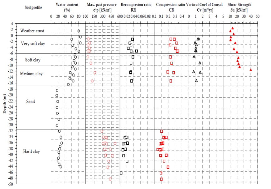
IntroductionThe ironic phrase used by (Antoljak 2020) may be best to define the process of formation of BIM with reference to geotechnical engineering ‘the BIM collaboration is increasingly being achieved via data stored in and shared in the cloud. Geotechnical data that has always been so much down to earth now needs to be looked up in the cloud’. BIM allows governments and Architecture/Engineering/Construction organizations to collaborate and transform any infrastructure asset into a computer model long before breaking the ground. Consequently, many conflicts can be identified and resolved in the model at a fraction of the cost it would require to correct the mistake in the field (Antoljak 2020). As reported by (Tawelian and Mickovski 2016) geotechnical engineers fully support the integration of geotechnical data into the BIM process, while the majority of them consider that this would provide significant cost and time savings in major infrastructure projects. (Valeria, Roberta et al. 2019) Successfully imported a big quantity of borehole data in BIM software which were lately used for the design of soil nail reinforcements. (Berdigylyjov and Popa 2019) Investigated the barriers of integration of geotechnical and structural data as a single BIM model. It was stated that one of the obstacles was that many geotechnical engineers are discouraged from sharing data for the fear of possible interpretive misuse. (Fabozzi, Biancardo et al. 2021) performed a “3D BIM to finite element model (FEM) to BIM analysis” for a tunnel excavation case study. By the completion of the analysis the fourth dimension for project management was also added to the numerical model. It was shown that the existing 3D FEM software’s are not still mature enough for such complex systems and more improvement is necessary in this area. (Xu and Wang 2020) Used 3D geological modeling to conduct preliminary investigation of geotechnical survey results. (TUDublin and Brennan 2021) Conducted a case study on applying BIM for coastal infrastructure projects and proposed a potential of a 40 percent saving in capital budget. (Vaníček, Jirásko et al. 2021) State that by incorporation of BIM in geotechnical engineering along with 3D Geotechnical structure model, the necessary base for the future decision making would be created especially when some changes occur in the projects. (Goyal, Rai et al. 2022) Emphasized the revolutionary impact of BIM and transportation geotechnical engineering. (Bradley, Li et al. 2016) in a review highlighted the developing base of BIM for infrastructures from preliminary analysis to construction site and state that with the increasing complexity, Information uniqueness and governance requirements of infrastructure projects graph based technologies and distributed data environments are the way forward in meshing together and leveraging the vast amount of data produced by modern day architecture, engineering, construction, owner and operator Projects.Soils with poor geotechnical properties, such as weak clays, require improvement technique applications. Surcharge preloading along with PVDs is a very common technique nowadays and can be seen nearly in all section from urban to industrial industry, expanding to any location regardless of undesirable ground condition where it might be weak pits or expansive and sensitive marine clays. Since clays and peats have very low hydraulic conductivities, PVDs which have high hydraulic conductivity and high bending strength, are widely used in soft subsoil improvement. PVDs alter the drainage pass from vertical direction to horizontal, and accelerate the primary consolidation of soft ground. The basic concept of preloading is the reduction of weak soils void ratio through consolidation by applying pressure on ground surface for a predetermined time period and then removing whole or a part of embankment for construction of a permanent super structure. . A key design feature of prefabricated vertical drains (PVDs) use is to accelerate consolidation and increase shear strength of the weak, fine-grained foundation soil(Stark, Ricciardi et al. 2018) but care should be taken in real assessment of real behavior of the embankment. In the case of shortage of time, supplementary methods such as vacuum preloading might be applied as well. In such a case preloading consists of combined vacuum and surcharge preloading. Because of excessive downward and lateral forces, PVDs should be very flexible in nature otherwise the drainage capacity would be decreased or lost and in such a case differential settlement is unavoidable. In recent years new generations of PVDs with higher discharge capacity and strength were introduced like (Fu and Chai 2020, Zhang, Chen et al. 2020). Overestimation and false assumptions in design are the main factors which lead to embankment failures in most of the reported cases (Tan and Liew 2000, Hayashi, Nishimoto et al. 2011, Stark, Ricciardi et al. 2018).After preliminary site investigation and superstructure designation, based on project time schedule and cost, the soil treatment procedure is defined. Since such projects are often big-scale inherently, all parts from design to field executive operations are divided between different teams and smaller companies. Because of this inevitable division in responsibilities, there are always many clashes and inconsistencies between design offices and also between design sheets and field executive operations. This article discussed the importance of collaboration that should exist between structural and geotechnical designers and executive engineers. Two important items such as the infiltrated layer and the behavior of treated soil including PVDs in different phases of construction is discussed that is often neglected even in mega projects, and have the potential to become the reason for catastrophic failures in such projects.