Edwin Sumargo

and 3 more

Capturing watershed-scale runoff response remains difficult, in part because of heterogeneous land surface characteristics in mountainous regions. This challenge has impacted our progress in understanding soil moisture role in modulating rainfall-runoff process. Situated in Northern California, the Russian River watershed is frequented by atmospheric rivers (ARs) that bring most of the significant rainfall events to the area and are associated with almost all of the floods. To observe the precipitation in this watershed, NOAA Hydrometeorology Testbed has installed 14 telemetered stations across the watershed since 2005, each with 2-minute soil moisture volumetric water content (VWC) sensors at 6 depths. The Center for Western Weather and Water Extremes at the University of California San Diego has installed 6 more stations since 2017. Understanding soil moisture variability is crucial for hydrologic modeling and operations, particularly flood prediction. This high resolution soil moisture observation network allows comprehensive analysis of soil moisture variability. For instance, correlation analysis of 2-minute VWC at 10-cm depth reveals a uniform shallow-layer soil moisture behavior with correlations of >0.8 at most locations and across different seasons, demonstrating the network’s utility in capturing spatial and temporal soil moisture variabilities. Following this result, we investigate how antecedent soil moisture condition modulates the rainfall-runoff process. We include precipitation and stream discharge records from the same stations and nearby USGS gauges. A series of AR events in February 2019 offers a prime example. The February 2nd and Valentine’s Day ARs saturated the soil in most parts of the watershed and resulted in minor flooding. Percentile rank analysis indicated the subsequent February 26th-27th ARs recorded the highest event total rainfalls since 2017 at most gauges. Consequently, the February 26th-27th ARs resulted in rapid runoff responses and widespread flooding. This example also reveals the spatial variation in antecedent soil moisture VWC “threshold” where runoff generation becomes efficient. Work is ongoing to profile this threshold variation within the watershed, and preliminary analysis suggests a range from <0.2 to >0.5 at 10-cm depth.

Hilary K McMillan

and 2 more

Dominant processes in a watershed are those that most strongly control hydrologic function and response. Estimating dominant processes enables hydrologists to design physically realistic streamflow generation models, design management interventions, and understand how climate and landscape features control hydrologic function. A recent approach to estimating dominant processes is through their link to hydrologic signatures, which are metrics that characterize the streamflow timeseries. Previous authors have used results from experimental watersheds to link signature values to underlying processes, but these links have not been tested on large scales. This paper fills that gap by testing signatures in large sample datasets from the U.S., Great Britain, Australia, and Brazil, and in Critical Zone Observatory (CZO) watersheds. We found that most inter-signature correlations are consistent with process interpretations, i.e., signatures that are supposed to represent the same process are correlated, and most signature values are consistent with process knowledge in CZO watersheds. Some exceptions occurred, such as infiltration and saturation excess processes that were often misidentified by signatures. Signature distributions vary by country, emphasizing the importance of regional context in understanding signature-process links and in classifying signature values as ‘high’ or ‘low’. Not all signatures were easily transferable from small- to large-scale studies, showing that visual or process-based assessment of signatures is important before large-scale use. We provide a summary table with information on the reliability of each signature for process identification. Overall, our results provide a reference for future studies that seek to use signatures to identify hydrological processes.

Tom E Botterill

and 1 more

Hydrologic signatures are quantitative metrics that describe a streamflow time series. Examples include annual maximum flow, baseflow index and recession shape descriptors. In this paper, we use machine learning (ML) to learn an optimal equivalent of hydrologic signatures, and use the learnt signatures to build rainfall-runoff models in otherwise ungauged watersheds. Our model has an encoder-decoder structure. The encoder is a convolutional neural net mapping historical flow and climate data to a low-dimensional vector encoding describing watershed function. The encodings are analogous to hydrological signatures. The decoder uses a process-informed network structure to predict streamflow based on current climate data, stored watershed state, static watershed attributes and the encoding. The decoder structure includes stores and fluxes similar to a classical hydrologic model. For each timestep, the decoder predicts coefficients that distribute precipitation between stores and store outflow coefficients. The model is trained end-to-end on the U.S. CAMELS watershed dataset to minimize streamflow error . Using learnt signatures as input to the process-informed model improves prediction accuracy over benchmark configurations that use classical signatures or no signatures. Median NSE performance on 100 watersheds excluded from the training set was 0.69. The process-informed model structure simulates hydrologic dynamics such as snow accumulation and melt, quickflow and baseflow. We interpret learnt signatures by correlation with classical signatures, and by using sensitivity analysis to assess their impact on modeled store dynamics. We conclude that process-informed ML models and other applications using hydrologic signatures may benefit from replacing expert-selected signatures with learnt signatures.

Ryoko Araki

and 3 more

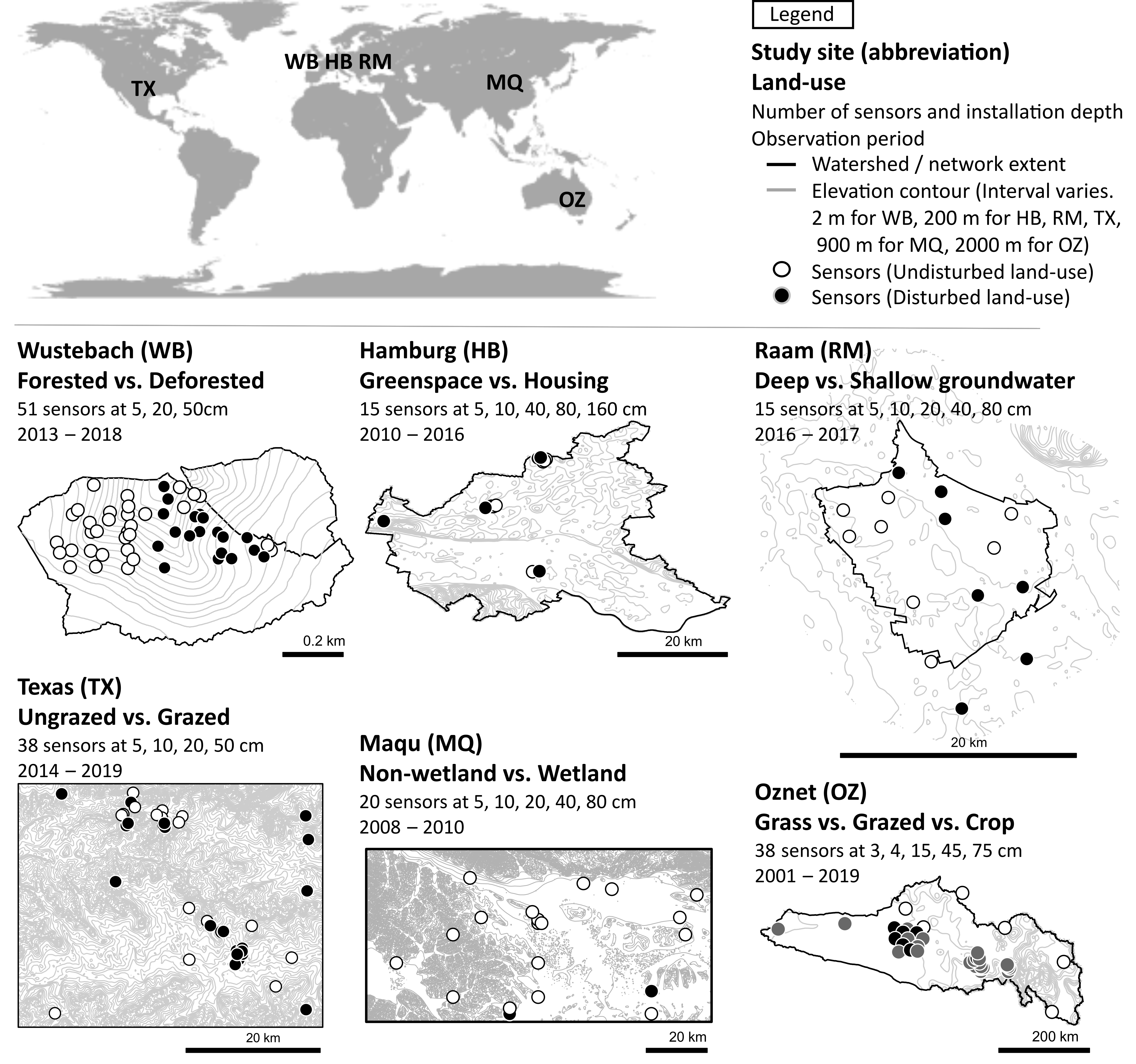
Soil moisture signatures provide a promising solution to overcome the difficulty of evaluating soil moisture dynamics in hydrologic models. Soil moisture signatures are metrics that quantify the dynamic aspects of soil moisture timeseries and enable process-based model evaluations. To date, soil moisture signatures have been tested only under limited land-use types. In this study, we explore soil moisture signatures’ ability to discriminate different dynamics among contrasting land-uses. We applied a set of nine soil moisture signatures to datasets from six in-situ soil moisture networks worldwide. The dataset covered a range of land-use types, including forested and deforested areas, shallow groundwater areas, wetlands, urban areas, grazed areas, and cropland areas. Our set of signatures characterized soil moisture dynamics at three temporal scales: event, season, and a complete timeseries. Statistical assessment of extracted signatures showed that (1) event-based signatures can distinguish different dynamics for all the land-uses, (2) season-based signatures can distinguish different dynamics for some types of land-uses (deforested vs. forested, urban vs. greenspace, and cropped vs. grazed vs. grassland contrasts), (3) timeseries-based signatures can distinguish different dynamics for some types of land-uses (deforested vs. forested, urban vs. greenspace, shallow vs. deep groundwater, wetland vs. non-wetland, and cropped vs. grazed vs. grassland contrasts). Further, we compared signature-based process interpretations against literature knowledge; event-based and timeseries-based signatures generally matched well with previous process understandings from literature, but season-based signatures did not. This study will be a useful guideline for understanding how catchment-scale soil moisture dynamics in various land-uses can be described using a standardized set of hydrologically relevant metrics.