Liqiang Deng

and 4 more

Streamflow in semiarid area is facing rapidly decreasing, especially in North China, which make it important to analyse the characteristics and influencing factors of streamflow. Using hydro-meteorological data series during 1961-2017 in the Upper Yongding River Basin (UYRB)( including Yang River Basin (YRB) and Sanggan River Basin (SRB)), Spatio-temporal variation characteristics of air temperature, precipitation and potential evapotranspiration (E 0) were analysed. Results showed that: precipitation has no significant trend; temperature shows a significant increase by 0.09–0.52℃ per decade; E 0 shows a significant decrease from -0.18 mm/yr to -2.04 mm/yr (in 18 stations); the estimated rates of streamflow change are –0.74, –0.80mm/yr for SRB and YRB. As to spatial distribution: the YRB presents a higher E 0 value than the SRB; and the mountain area has more precipitation than the plain area. And the change points of streamflow occurred in 1982 and 2003. Both Budyko and DMC method were used to evaluate the impacts of climate change and human activities on mean annual streamflow. In the variation stage Ⅰ (1983~2003), impacts of human activities account for 90.6% and 62.7% of the mean annual streamflow changes in YRB and SRB, respectively. In the variation stage Ⅱ (2004~2017), the percentages are 99.5% and 93.5%, respectively. It is also noted that the first change point in streamflow was indeed at the beginning of China’s land reform, when the farmers can manage their reallocated lands and therefore increased agricultural water consumption. The second change point coincided with “Capital Water Resources Planning” including water conservation projects and irrigation district construction programs. In general, human activities were mainly responsible for the significant decline in the annual streamflow of UYRB. This paper will provide valuable results for water resources planning and give guidance to the construction of water conservation function area and ecological environment support area of capital.

qiangli deng

and 4 more

Streamflow plays a key role in ecosystem and human society, which make it important to analyse the characteristics and influencing factors of streamflow. Using hydro-meteorological data series during 1961-2017 in the Upper Yongding River Basin (UYRB)( including Yang River Basin (YRB) and Sanggan River Basin (SRB)), Spatio-temporal variation characteristics of air temperature, precipitation and potential evapotranspiration (E 0) were analysed. Results showed that: precipitation has no significant trend; temperature shows a significant increase by 0.09–0.52℃ per decade; E 0 shows a significant decrease from -0.18 mm/yr to -2.04 mm/yr (in 18 stations); the estimated rates of streamflow change are –0.74, –0.80mm/yr for SRB and YRB. As to spatial distribution: the YRB presents a higher E 0 value than the SRB; and the mountain area has more precipitation than the plain area. And the change points of streamflow occurred in 1982 and 2003. Both Budyko and DMC method were used to evaluate the impacts of climate change and human activities on mean annual streamflow. In the variation stage Ⅰ (1983~2003), impacts of human activities account for 90.6% and 62.7% of the mean annual streamflow changes in YRB and SRB, respectively. In the variation stage Ⅱ (2004~2017), the percentages are 99.5% and 93.5%, respectively. It is also noted that the first change point in streamflow was indeed at the beginning of China’s land reform, when the farmers can manage their reallocated lands and therefore increased agricultural water consumption. The second change point coincided with “Capital Water Resources Planning” including water conservation projects and irrigation district construction programs. In general, human activities were mainly responsible for the significant decline in the annual streamflow of UYRB. This paper will provide valuable results for water resources planning and give guidance to the construction of water conservation function area and ecological environment support area of capital.

Liqiang Deng

and 3 more

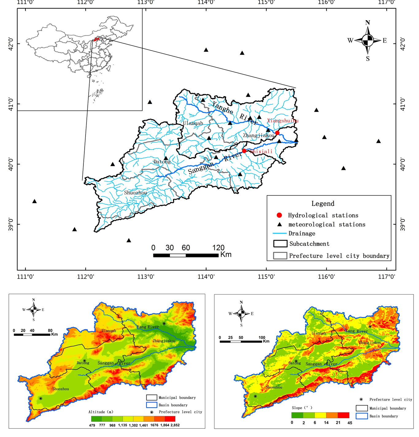
Quantitative assessment of the effects of climate change and human activities on runoff is very important for regional sustainable water resources utilization. Determining abrupt changes in runoff could enhance identification of the main driving factors for the sudden changes. In this study, the double mass curves analysis combined with field investigation is used to determine abrupt changes in runoff in two sub-catchments of Upper Yongding River Basin(UYRB), while trend analysis via the traditional Mann–Kendall test for the period 1961–2017 is used to identify the basic trend of precipitation, temperature and potential evapotranspiration(E0). The results suggest an insignificant change in precipitation, a significant increase in temperature and a significant decline in E0 in both sub-catchments. For both of the sub-catchments, abrupt changes in runoff occurred in 1982 and 2003. Both Budyko’s curve and double mass curves are used to evaluate the potential impacts of climate variability and human activities on mean annual streamflow. The results showed that, from the 1960s to the 1980s, runoff declined by 20.01% and 22.28% for Xiangshuibu and Shixiali, respectively; from the 1980s to the 2000s, runoff declined by 68.23% and 67.77% respectively. In the variation stage Ⅰ (1983~2003), human activities contributed 90.6% and 62.7% of the mean annual streamflow change in YRB and SRB, respectively. In the variation stage Ⅱ(2004~2017), human activities contributed 99.5% and 93.5% of the change in YRB and SRB, respectively. It is also noted that the first abrupt decline in runoff was actually at the beginning of China’s land reform, when the land reform motivated farmers to productively manage their reallocated lands, agricultural water consumption therefore increased. The second abrupt change point occurred in 2003, when “Capital water resources planning” implemented including water conservation projects and irrigation district construction. In general, human activities, including soil and water conservation projects and water consumption, are found to be the dominant factors responsible for the significant decline in the annual streamflow in the UYRB over the last six decades.