Peter J Haeussler

and 4 more

We present the crustal fault model for Alaska, based on geologic observations, as a primary input for the 2023 revision of the U.S. Geological Survey National Seismic Hazard Model (NSHM). We update the 2013 Alaska Quaternary fault and fold database (Koehler, 2013) with subsequent findings to produce a simplified model of 105 fault sections and four fault zone polygons with basic geologic parameters including slip sense and rate. Significant updates from prior maps include: 1) A slip rate of ~53 mm/yr on the Queen Charlotte Fault system indicating it accommodates all of the plate boundary motion. 2) Quantified long-term slip rates on megathrust splay faults in the southern Prince William Sound region and near Kodiak Island. 3) Improved details of structures in the Chugach-St. Elias orogen. 4) Revised characterization of Castle Mountain Fault from right-lateral slip to a predominantly reverse fault. 5) Improved Interior Alaska tectonic models that clarify relationships between the Denali Fault, Totschunda Fault, and thrust faults on both sides of the Alaska Range. 6) Identified large earthquake sources in the eastern Brooks Range. 7) Omission of the Chatham Strait section of the Denali Fault. We also describe the growing body of Alaskan lacustrine paleoseismic records of strong shaking, which may offer a test of ground motion recurrence predicted by the 2023 NSHM for crustal, megathrust, and intraslab events. The fault model underscores that the collision of the Yakutat microplate is the dominant driver of active crustal faulting in most of Alaska.

Drake M Singleton

and 4 more

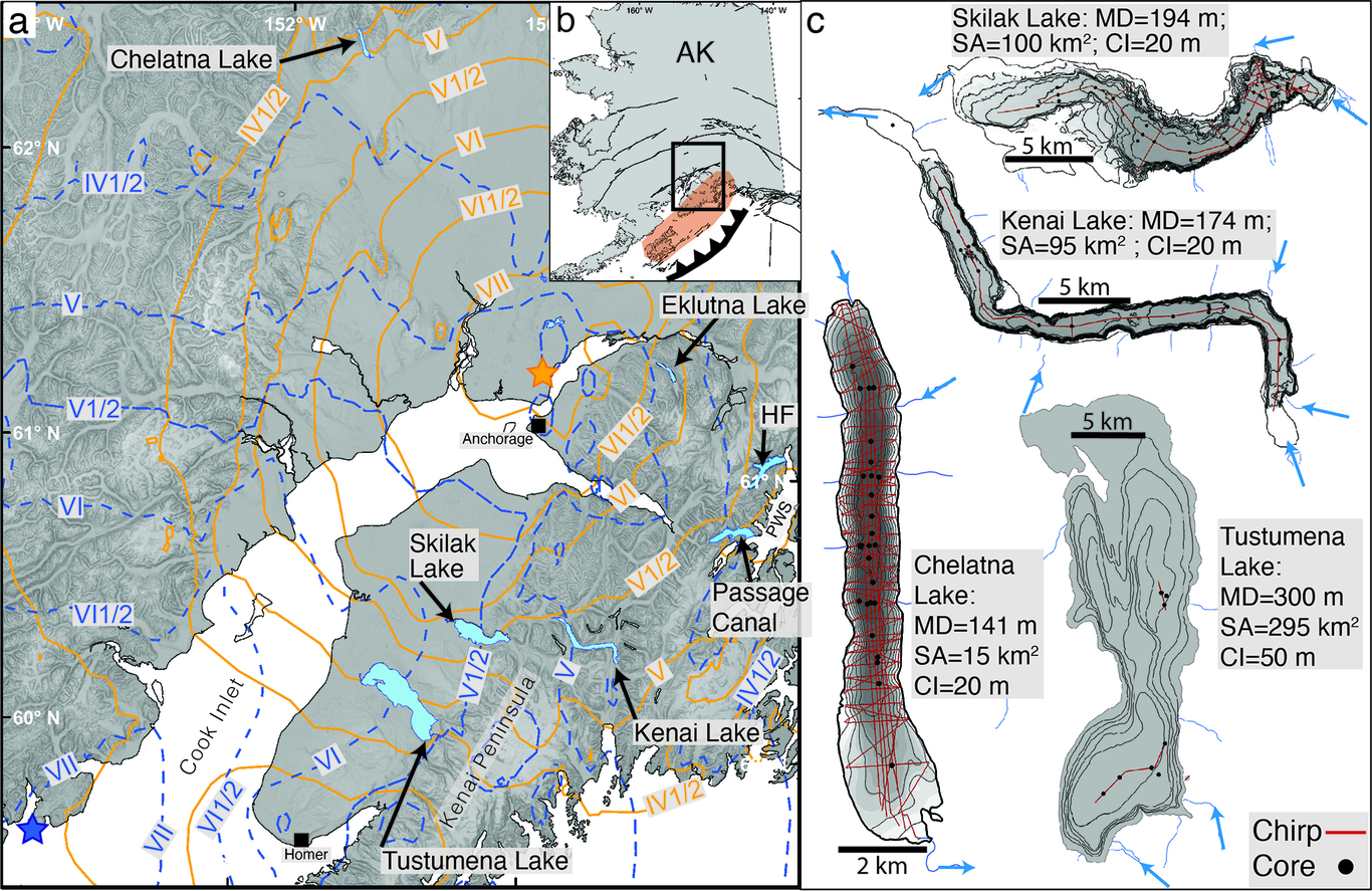
Intraslab earthquakes do not produce primary paleoseismic evidence at the Earth’s surface, making efforts to develop an event chronology challenging. However, the strong ground motion from intraslab events may initiate gravity-driven turbidity flows in subaqueous basins; the resulting deposits (turbidites) can provide a paleoseismic proxy if the conditions that initiate these flows are known. To better constrain the initiating conditions, we use two recent intraslab earthquakes in southcentral Alaska, the Mw 7.1 November 30, 2018, Anchorage and the Mw 7.1 January 24, 2016, Iniskin earthquakes, as calibration events. Through a multi-lake investigation spanning a range of shaking intensities and based on a combined geological and geophysical dataset, we document the occurrence, or absence, of earthquake-generated turbidity flows from these two earthquakes. The 2018 and 2016 earthquakes are recorded by centimeter-scale turbidites that can be differentiated from climatically generated deposits, as well as other seismic sources (i.e., the 1964 Alaska megathrust earthquake) based on deposit thickness, sedimentological properties, and deposit age. We show that a Modified Mercalli Intensity (MMI) of ~V-V1/2 is the minimum shaking intensity required to generate localized sediment remobilization from deltaic slopes, and a MMI of ~V1/2 is required to produce a deposit of sufficient thickness that a seismic origin can be confidently assigned. Deltaic slopes are the major source of remobilized sediment that record the 2018 and 2016 events, however sediment from non-tributary sourced basin slopes may become remobilized in steep-sloped, high sedimentation areas, and under elevated shaking intensity. The documentation of seismically generated deposits in quick succession (~2 years) with diagnostic features that can be assigned to the seismic source highlights the utility of using recent earthquakes as calibration events to investigate the subaqueous response to strong ground motion. 

Bretwood Higman

and 17 more

A slope at Barry Arm, in Alaska’s Prince William Sound, is deforming at a varying rate up to tens of meters per year above a retreating glacier and deep fjord that is a popular recreational destination. If the estimated 500 million cubic meters of unstable material on this slope were to fail catastrophically, the impact of the landslide with the ocean would produce a tsunami that would not only endanger those in its immediate vicinity, but likely also those in more distant areas such as the port of Whittier, 50 km away. The discovery of this threat was happenstance, and the response so far has been cobbled together from over a dozen existing grants and programs. Remotely sensed imagery could have revealed this hazard a decade ago, but nobody was looking, highlighting our lack of coordination and preparedness for this growing hazard driven by climate change. As glaciers retreat, they can simultaneously destabilize mountain slopes and expose deep waters below, creating the potential for destructive tsunamis. The settings where this risk might occur are easily identified, but more difficult to assess and monitor. Unlike for volcanoes, active faults, landslides, and tectonic tsunamis, the US has conducted no systematic assessment of tsunamis generated by subaerial landslides, nor has the US established methods for monitoring or issuing warnings for such tsunamis. The U.S. National Tsunami Warning Center relies on seismic signals and sea-level measurements to issue warnings; however, landslides are more difficult to detect than earthquakes, and the resultant tsunamis often would reach vulnerable populations and infrastructure before water level gages could help estimate the magnitude of the tsunami. Also, integrating precursory motion and other clues of an impending slope failure into a tsunami warning system has only been done outside the US (e.g Norway: Blikra et al., 2012). Barry Arm is a dramatic case study highlighting these challenges and may provide a model for mitigating the threat of tsunamis generated by subaerial landslides enabled by glacial retreat elsewhere.